homepage
rental-offer on the subject "maps" - issue Sunday, December 4th, 2016
279 objects keywords airline to timeprofilm.de, Horst
Decker GbR,
Kirchbergstr.37, D-63691
Ranstadt (40km north of Frankfurt/Main),
Phone: 00496035-921685, Phone/Fax:00496035-1403, St.ID.:81 438 072 592, USt.-Nr. DE - 2258749
|


| order No | in use | description | rental |
|---|---|---|---|
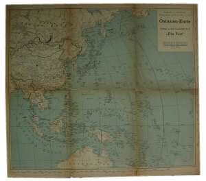
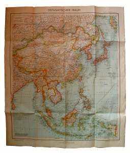
INo 14598 | 1940-1945 | German WW2 map of East Asia and the Pacific, 'Ostasien-Karte', issued around 1940, showing area betwenn the Nort-West Soviet river Ural down to Samoa Islands, folds week and partly tawn, heavily used condition | 15 € |
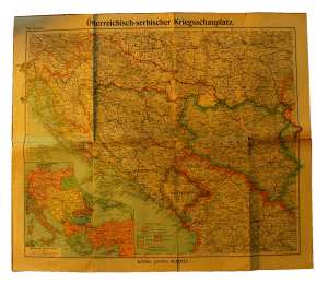
INo 6384 | 1900-1918 | Map of the Austrian-Serbian theatre World-War 1, by Gotha-Justus Pertes edition around 1916, coloured, East-Europe from 14-23° East / 46-41°North, 75x64cm, folds with tears | 15 € |
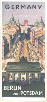
INo 11219 | 1935-1936 | Citymap of Berlin and Potsdam, issued from the German Railway-Company 1935 in English for tourists, 10x21 with 36 pages, map of the subway, the city and the region, describing the objects of interest, like new condition | 15 € |
INo 4088 | 1936-1950 | Coloured street-card of the gasoline-company Aral, issue 1936, open 52x45cm, folded 10x22cm, showing German areas Monschau- Alsfeld - Chateau Salins- Heilbronn, on its back city-maps | 15 € |
INo 4078 | 1955-1965 | Colourful German road map from the BP gasoline Co., around 1955, area Arnheim- Bielefeld- Luxemburg- Heidelberg, back area card of the Ruhr river area Kleve- Ahlen- Aachen- Bonn, 61x43cm, folded 15x22cm | 10 € |
INo 4079 | 1955-1965 | Colourised car map of Austria, issued by the gasoline-co. BP around 1955, area Eßlingen - Wien - Bergamo - Zagreb, back with plan of BP-stations in Austria, 61x43cm, folded 15x22cm | 10 € |
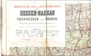
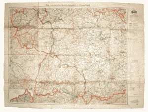
INo 10114 | 1910-1919 | Coloured German map 'Ravensteins Rad- und Automobilkarte von Hessen-Nassau Oberhessen und Waldeck', Hessian area, edition 'Ludwig Ravenstein Frankfurt' around 1910, missing bottom maps, some small holes, from Erwitte to Herzberg, Dierdorf, Meiningen | 20 € |
INo 4090 | 1955-1965 | Coloured road map of Swizzerland and bordering countries, issued by the oil Co Migrol around 1955, covering Belfort - Kempten, Lac du Bourget to Tirano, incl. network of gas stations, 87x46 cm, collapses to 11x23cm | 10 € |
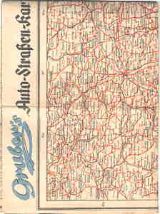
INo 11183 | 1940-1955 | Street-map 'Grubers Auto Straßen Karte', showing on both sides the areas of central to south Germany with some part of Switzerland, Austria, Czechoslovakia, licensed by the Allied Information Control, about 1948, good condition | 10 € |
INo 10115 | 1910-1919 | Coloured road map 'Ravensteins Spezial - Rad- und Automobilkarte ...' (Ravenstein's special bicycle and car road map of middle Europe), issued 1910, 73x57cm, area Nienburg - Stendal - Landau - Merseburg, missing 4 fields | 20 € |
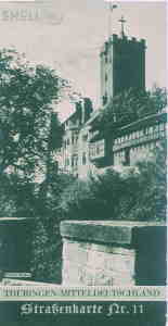
INo 11490 | 1936-1950 | Coloured street-card of the gasoline-company Shell, issue around 1938, open 45x44cm, folded 11x22cm, face with famous Wartburg castle showing, German areas Bielefeld. Helmstedt, Wetzlar and Ilmenau, on its back PR for Shell Germany | 10 € |
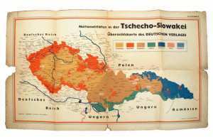
INo 12728 | 1935-1939 | Coloured map of Chechoslowakia of around 1938 prior German occupation, showing the different roots of the people, 74x42cm, folds torn and heavily used | 15 € |
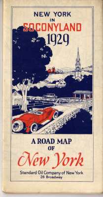
INo 8460 | 1929-1936 | 'New York in Seconyland', city-map of NY by the Secony-Standard Oil Co. 1929, opened 56x72cm, on its back street-index and recommendations for holiday-trips, like new | 15 € |
INo 10229 | 1975-1980 | City map of Berlin Germany, sights and maps, roads and boarder gates, tourist informations, issue July 1975, folded open 74x60cm, good condition with traces of use | 10 € |
INo 8485 | 1915-1919 | City-map of Vienna Austria, issue 1915, 7.5x11cm, 256 pages, no sketches but description of streets and their connections | 15 € |
INo 5860 | 1929-1940 | 'Continental Straßenkarte für Rad- und Kraftfahrer' (Continental road map for bicyclists and motor propelled drivers), issue June 1929, map 28 - area Leipzig, Stassfurt-Rabena, Jana-Dahme, 55x42cm, folded 18x11.5cm | 15 € |
INo 10944 | 1920-1930 | German street-map of Darmstadt, 3-colour-print, 60x78cm, issued by the Hessian cartographing-office 1920/1930, street-index, still the old airport shown, heavily used | 20 € |
INo 9849 | 1998-1998 | Sreet map 'Düsseldorf International', showing the area Düsseldorf incl. Ruhr-Area and Netherlands and Belgium, issued by the Düsseldorf Airport 1998, like new | 8 € |
INo 14167 | 1941-1945 | Colour-map of Eastern Asia, 77x89cm, 'Ural - Kamtschatka - Cylon - Neuguinea', issued July 1941 by the German Army Headquarter, scale 1:10 millions, good condition with traces of use and age | 15 € |
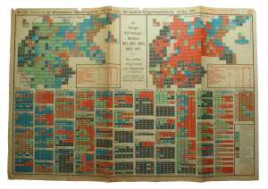
INo 14180 | 1914-1918 | German map of a series on WW1, issue No. 220 52/1918, colourful map showing the German Government elections 1871 to 1918 in graphics, parties and areas, back election law 30th of Nov. 1918, 50x34.5cm | 15 € |
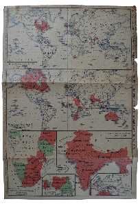
INo 15387 | 1914-1918 | German map of a series on WW1, issue No. 219 51/1918, colourful map showing the German and British colonies all over the world, 16th of Dec. 1918, 34.5x50 cm | 15 € |
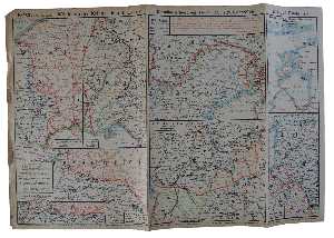
INo 15388 | 1914-1918 | German map of a series on WW1, issue No. 16, front between 22nd and 29th of Oct. 1917, Belgium, France, Austria, Italy and Balticum, back with describtion of events, 50x 34.5 cm | 15 € |
INo 9019 | 1935-1950 | Coloured map of the German Rhein-Ruhr area around the city Hagen, around 1938, 42x56cm, edition Flemmings Hamburg, good condition | 10 € |
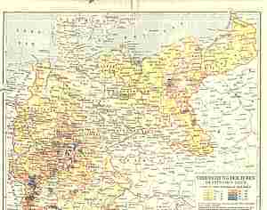
INo 2966 | 1937-1964 | Karte Mitteleuropas 'Deutschland in den Grenzen von 1937', Maßstab 1:3 Millionen, darin eingetragen die nach 1945 verlorenen und besetzten Ostgebiete, Rückseite 'geteilte Stadt Berlin' m.Wirtschaftsdaten, Herausgeber BRD 1964 | 10 € |
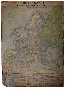
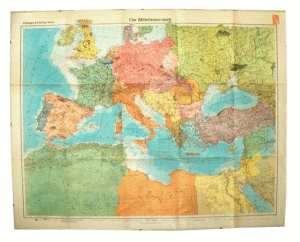
INo 9666 | 1940-1945 | Map of Europe, issued by the newspaper edition 'Deutsche Allgemeine Zeitung - Deutscher Verlag' Berlin 1940, scale 1:6 millions, fixed on cardboard 80x106cm, showing borders of 1939, used as shootig target many 4mm holes and one 9mm hole in Norway | 15 € |
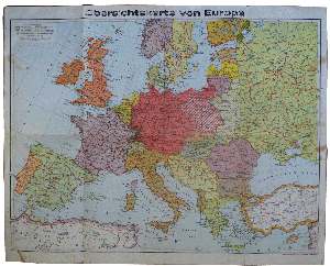
INo 15374 | 1940-1945 | Map 'total Europe', scale 1:7 millions, issued Brockhaus 1940, showing Europe from Eire to Liposk (North-Russia), Casablanca - Damaskus,63x51cm, little tears aon folds, used condition | 15 € |
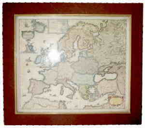
INo 2252 | 1630-1980 | Facsimile of a map of Europe of 1931, coloured, 48x40cm, in simple wide leather covered frame, total size 57x51x2cm, good condition | 15 € |
INo 2404 | 1947-1955 | City map of Frankfurt, issued Sept. 1947, showing all demolated and ruined areas of Allied bombing in WW2, edition Falk Landkarten Verlag, issued with permission of Allied Control-Office, good condition | 30 € |
INo 8130 | 1988-1990 | Map 'Reiseland DDR ...', tourist's land GDR (East Germany), scale 1:600 000, issued 13th of May 1988, 64x96cm, good condition | 15 € |
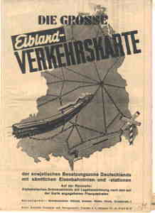
INo 1934 | 1947-1955 | German map, black-and white print 42x60cm, in German 'the big Elbeland Map of the Soviet Occupation Zone of Germany with all railway-connections and stations', folds to 15x21cm, back with register of all villages and cities of the SBZ (prior DDR) | 15 € |
INo 9930 | 1946-1950 | 'Atlanta Karte der Besatzungszonen ...' (Atlanta map of the occupation zones incl. postal codes), not dated, around 1946, 4-colour print, 60x40cm, printed by 'Schilling Heilbronn', one fold with tear | 14 € |

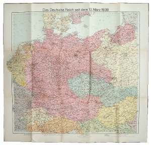
 INo 13951 | 1938-1945 | Coloured map of Germany after the annexion of Austria, edition Velhagen and Klasings, 74x71cm, with cover, map very good condition, covr used | 15 € |
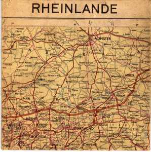
INo 10898 | 1946-1950 | German post WW2 map of the Rhine area 'Rheinlande', 47x66cm, Zevenaar - Detmold - Düdelingen - Heidelberg, 1946, school edition by Hans Witte Karlsruhe, the US, British and French occupation zone marked, good condition | 10 € |
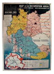
2 pieces available INo 8698 | 1946-1950 | Atlanta Map of the German Occupation Areas, not dated but probably 1946, 4-colour-print size 38x56cm, edition Schilling/ Heilbronn, bright colours, but some tears | 14 € |
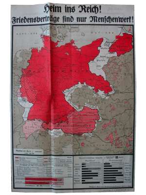
INo 12635 | 1920-1930 | Map of Germany and Austria showing the areas that were lost threw the peace treaty of Versailles 1919, issued 1924 by the organisation for uniting Germany and Austria 'Heim ins Reich', 30x46cm | 20 € |
INo 10159 | 1957-1960 | German map of the tourist place 'Bad Wiessee' alt lake Tegernsee in Bavaria, incl. a street map of village, 55x42cm, 1957, good condition | 8 € |
INo 9755 | 1928-1940 | General map from 1936, scale 1:100.000, 2 joined mapes (No 130 and 137) over each other, area Fischbach/Nahe - Osthoven - Monswiller/France - Staufenberg/Baden, 88x120cm, worn condition | 10 € |
INo 10163 | 1931-1945 | Map of the German tourist city 'Badenweiler', issued 1931, coloured city view showing all hotels, pensions and streets, register of houses and railway connections, 62x46cm, torn in fold | 15 € |
INo 12250 | 1946-1950 | German map of post WW2 the French occupied Germany, issued Sept. 1947, 110x80cm, scale 1:500.00, area Malmedy-Plauen- Luxeuil- Basel- Kufstein, used condition | 14 € |
INo 5862 | 1964-1990 | Big road map of East Germany 'Verkehrskarte Deutsche Demokratische Republik', scale 1:500.000, on white linen 78x106cm, folds to 27x20cm, top with hanger, made by 'VEB Hermann Haack K8/57 Gen.Nr.1156/64 10/64 12000', wrong assembled 1 element double | 15 € |
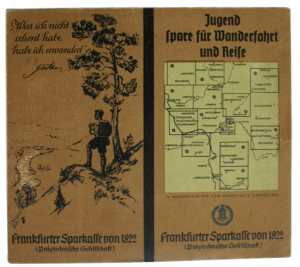
2 pieces available INo 14594 | 1930-1950 | Booklet 22.5x20 with city map of Frankfurt a.M. and aera of around 150km arround it, 14 maps, issued by the Frankfurt bankhouse 'Sparkasse von 1822', around 1930, very good condition | 15 € |
INo 7834 | 1946-1950 | German map from 1st Febr. 1946, showing the 4 occupation-zones of Germany, 60x42, scale 1:1.400.00, good condition | 20 € |
INo 10883 | 1946-1950 | German map 'Besatzungszonen u. Postleitgebiete in Deutschland' (occupation zones and postal areas in Germany), issued in Berlin 1946, 4-colour print exposing the Allied zones, postal areas and city codes | 14 € |
INo 13920 | 1944-1950 | German of the German Reichsbahn July 1944, 96x55cm, map Europe from Borkum - Minsk - Strassbourg to Czernowitz, backside only railway connections but close all Europe Brest - Pleskau - Saragossa - Sofia, thin paper | 20 € |
INo 4985 | 1942-1960 | 3-colour map 'verbrannte Erde' (burned ground), showing East-Europ in the borders of 1937 with the front line of 1942, was supplement of an dictonary of 1950, 31x34cm | 10 € |
INo 10161 | 1909-1920 | Map of the German Reich, issue 'Bad Reichenhall' sheet 190 from 1909, 46x43cm, scale 1:200000, good condition with traces of use | 15 € |
|
| |||
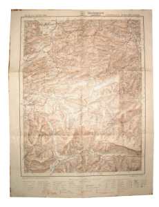
INo 10157 | 1916-1940 | German map 'Atlas von Bayern 1916' (altlas of Bavaria 1916), sheet 93 city 'Reit und Winke', covering the area Grassau, Ruhpolding, Erpfendorf, Eiblhorn, revised issue of 1932, 48x61cm, good condition | 15 € |
INo 4329 | 1900-1934 | German map 30x24cm, in German 'the population of Jews in Germany', issue from 1900, was part of the Meyers Encyclopaedia issue 6, very good condition | 20 € |
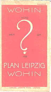
INo 11308 | 1950-1970 | Citymap of Leipzig Germany, issued about 1948/1950, 3-colour print, 48x64cm, on its back the old 3rd Reich street names and the new post-war names, edition Moritz Ruhl, good condition with traces of use | 10 € |
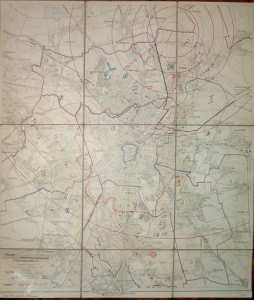
INo 11949 | 1927-1933 | Citymap of Leipzig Germany, issued 1927, showing the social housebuilding after WW1 and the Leipzig Airschip and Aeroplane port with low approaching zone, 50x58cm, good condition | 20 € |
INo 12740 | 1941-1945 | German map of the Mediterranean Sea, edition Velhagen & Klasings 1941, showing the political hemisphere of the area Ireland- Kasakhstan- Marocco- Saudi Arabia, 108x84cm, good condition | 10 € |
INo 7773 | 1942-1945 | German street map of unidentified city on Memel river (certainly not Tilsit)right of Memel caserne and 'Reichsbrücke', printed after sketch om 21x30 cm papersheet, around 1943, scale 1:10.000 | 10 € |
INo 7774 | 1939-1945 | German WW2 map 'Schlag nach über das Mittelmeer' (inform yourself about the Middleterainian Sea), 1939/40, 112x46cm, showing the complete middleterainian sea and black sea with countries and French and British navy-bases | 20 € |
INo 6659 | 1995-1998 | Citymap of Munich 'Wegweiser zur Messe' (streetplan to the fair', issue Dec. 1995, 32 pages 10x21cm, connections by plane, tube, taxi, railway and car, plan of fair | 6 € |
INo 9754 | 1932-1932 | Sea map of the North-Atlantic, monthly issue Sept. 1932, showing ice trails and sinked ships, steamer routs and weather situations, 107x74cm, folded, good condition | 10 € |
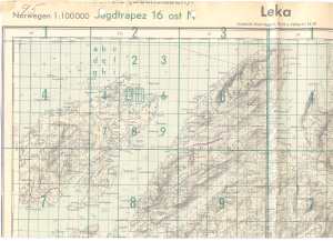
INo 10296 | 1940-1945 | German Airforce (Luftwaffe) map page 6129 'Jagdtrapez 16 ost N - Sonderausgabe XI.1940 - Leka/Norwegen 1:100000', from the battle of Norway, with air-navigation net, left and right frame shorted, 48x78cm, issue of 1944, good condition with traces of us | 15 € |
INo 9550 | 1940-1945 | Wehrmachts map, special edition 'IV.1940 - Saldal Norway 1:100000', right side explanations of symbols, 70x100cm, edges worn otherwise good condition | 15 € |
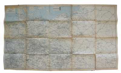
INo 7885 | 1935-1950 | Coulored road map of Germany, area Nurnberg - Wurzburg - Bamberg - Regensburg, issue Jan. 1935, 80x64cm, scale 1:300.00, shows German road signs, good condition | 15 € |
INo 7771 | 1946-1950 | Allied Military Government map of Germany 'Atlanta map of the German occupation areas ...', Milit. Gov. 27.09.1946, 4-clour print 60x40cm, printed by 'Holterdorf/Oelde' | 14 € |
INo 8978 | 1972-1972 | Official special-map from the Olympic Games 1972 in Munich, the city-map with all sports-arenas, time-schedule, symbols and offices, edition 'Maiers Geografischer Verlag' | 10 € |
3 pieces available INo 5134 | 1938-1951 | Instruction sheet 'Musterblatt und Zeichenerklärung für die Karte des Deutschen Reiches' how to read the map of Germany, what the symbols mean, issued 1938 but reprint of 1951, uncut as it came off the press | 15 € |
INo 5135 | 1955-1960 | Printing sheet from a around 1955 re-issue of the German 1937 map but with marked Soviet Occupation Zone and Poland and Schlesia, scale 1:100000, issue C | 15 € |
INo 292 | 1943-1945 | US pilots map N53 'Berlin' Germany 1:250.000, issue 1943, area Wusterhausen to Beeskow, gaze-enforced waxpaper, very good condition | 20 € |
INo 298 | 1943-1945 | US pilots map L52 'Kassel', Germany 1:250.000,issue 1943, area Gütersloh to Sontra, gaze enforced waxpaper, very good condition | 20 € |
INo 283 | 1943-1945 | American war-pilots map N51 'Chemnitz' - Germany 1:250.000 of 1943, showing the area Altenburg to Kladno/CSSR, waxpaper, like new condition | 20 € |
INo 289 | 1943-1945 | US pilots map K51 'Köln', Germany scale 1:250.000, issue of 1943, area Köln to Wiesbaden, gaze enforced paper, very good condition | 20 € |
INo 297 | 1943-1945 | US pilots map L48 'Konstanz', Germany 1:250.000, issue 1943, area Donau-Eschingen to Bludenz, waxed paper, very good condition | 20 € |
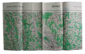
INo 14146 | 1943-1945 | US WW2 aeronautical map P50 'Brno' - Central Europe 1:250.000 of 1944, paper not sealed, dealing the area Wildenschwert - Troppau - Eibenschitz - Pucho, 88x63cm, very good and unused condition | 20 € |
INo 288 | 1943-1945 | US pilots map N52 'Dresden', Germany, scale 1:250.000, issue of 1943, area Coswig to Dresden, waxpaper, very good condition | 20 € |
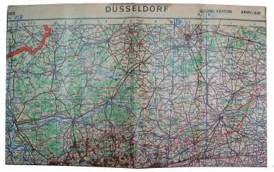
INo 299 | 1943-1945 | US pilots map K52 'Düsseldorf', Germany 1:250.000, issue 1943, area South-East Netherlands to Olpe, waxed paper, very good condition | 20 € |
INo 285 | 1943-1945 | US pilots map M51 'Erfurt' Germany, scale 1:250.000, issue of 1943, area Gotha to Selb, waxpaper, very good condition | 20 € |
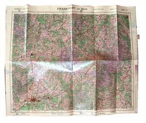
INo 290 | 1943-1945 | US pilots map L51 'Frankfurt a. Main', Germany scale 1:250.000, area Laaspe to Schweinfurt, issue 1943, waxed paper, very good condition | 20 € |
INo 5962 | 1940-1945 | German pilot's map of 1937, issue 10A (East Anlia - Amsterdam), Eastern Britain 0-6 degrees east (London - Liege), 50-54 degrees North (Cambrai - Spurn Head), 86x90cm, folio covered, hand written note in German 'from Eindhoven '1) 285deg, 2.) 200deg. 3. | 20 € |
INo 5964 | 1937-1945 | German pilots-map of Germany and neighbour-countries, issue 20th Febr. 1937, 6° -23° East, 47°-55,5° North, registrated ADF-stations, 66x49cm, used condition | 15 € |
INo 305 | 1943-1945 | US WW2 aeronautical map O52 'Görlitz' - Central Europe 1:250.000 of 1943, dealing the area South Denmark to Wolgast, waxpaper, very good condition | 20 € |
INo 293 | 1943-1945 | US pilots map M52 'Halle' Germany 1:250.000, issue 1943, area Goslar to Zeitz, gaze enforced waxpaper, very good condition | 20 € |
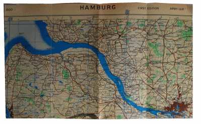
INo 296 | 1943-1945 | US pilots map L54 'Hamburg', Germany 1:250.000, issue 1943, area Neuwerk to Munster, gaze enforced waxed paper, very good condition | 20 € |
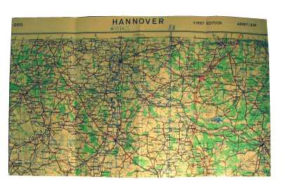
INo 303 | 1943-1945 | US pilots map L53 'Hannover', Germany 1:250.000, issue of 1943, area Harpstedt to Hildesheim, gaze-enforced waxpaper, very good condition | 20 € |
INo 282 | 1943-1945 | American air-map M48 'Innsbruck' Germany 1:250.000 of 1943, area Ammersee to Zillertal, wax-paper, very good and like new | 20 € |
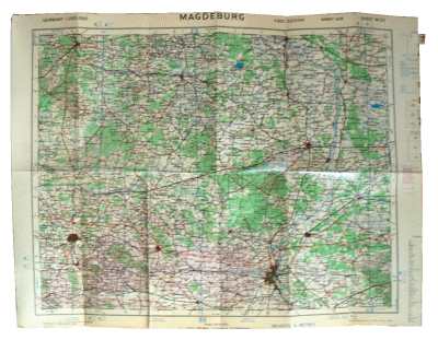
INo 300 | 1943-1945 | WW2 US air-map of German Magdeburg area, map M53 1943 scale 1:250.000, linen enforced waxpaper, like new condition | 20 € |
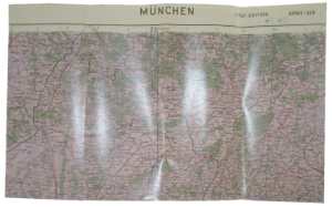
INo 284 | 1943-1945 | US pilots map M49 'München' - Germany Munich, scale 1:250.000, issue of 1943, area Nördlingen to Wasserburg, waxpaper, very good condition | 20 € |
INo 302 | 1943-1945 | US pilots map N54 'Neustrelitz', Germany 1:250.000, issue of 1943, area Gnoien to Schwerdt, gaze-enforced waxpaper, very good condition | 20 € |
INo 294 | 1943-1945 | US pilots map M50 'Nürnberg', Germany 1:250.000, issue 1943, area Gerolzhofen to Regensburg, gaze-enforced waxpaper, very good condition | 20 € |
INo 291 | 1943-1945 | US pilots map K54 'Oldenburg' Germany 1:250.000, WW2 issue of 1943, area Borkum to Oldenburg, gaze enforced wax-paper, very good condition | 20 € |
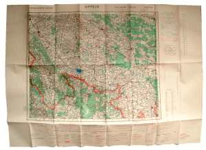
INo 12745 | 1943-1945 | US WW2 aeronautical map P51 'Oppeln' - Central Europe 1:250.000 of 1943, dealing the area Striegau - Kreuzburg - Senftenberg - Ratibor, 88x63cm, very good and unused condition | 20 € |
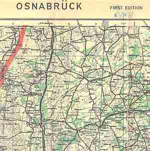
INo 295 | 1943-1945 | American WW2 map No K53 'Osnabrück - Germany 1:250 000' Army/Airforce 1943, showing western Netherlands to Versmold, gaze-strengthened wax-paper, unused and like new condition | 20 € |
INo 304 | 1943-1945 | US pilots map N49 'Passau', Germany 1:250.000, issue of 1943, area Straubing to Linz, waxpaper, very good condition | 20 € |
INo 287 | 1943-1945 | US pilots map M55 'Rostock' Germany, scale 1.250.000, issue of 1943, area South-East Denmark to Rostock, waxpaper, very good condition | 20 € |
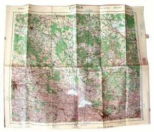
INo 306 | 1943-1945 | Schedule of the us pilots maps 'Conventional Sign. Card', 14x24cm, issue 1944 for Netherlands and Germany, 1:100.000, with contours of the countries and explanations | 10 € |
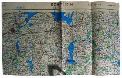
INo 301 | 1943-1945 | US pilots map M54 'Schwerin', Germany 1:250.000, issue of 1943, area Lübeck to Perleberg, waxpaper, very good condition | 20 € |
INo 286 | 1943-1945 | US pilots map N55 'Stralsund'- Germany 1:250.000, issue of 1943, area South-East Denmark to Wolgast, waxpaper, very good condition | 20 € |
INo 2219 | 1936-1936 | Pocket-map of the German KdF (Kraft durch Freude) organisation 1936, 40 coloured maps of the German Reich and Europe, 13.5x10cm, in the post WW2 time neutral paper glued over title and back, this mostly removed again | 10 € |
INo 9711 | 1821-1830 | Map, probably a facsimile, 57x53cm, post coach connections 1821 of Thurn&Taxis Co, from Trier to Praque, North-Sea and Baltic Sea, good condition | 25 € |
|
| |||